

| Home | Communities | Accommodations | Places To Go | Things To Do | Site Map |
|
Glacier Country
Central Montana
Missouri River Country
Southwest Montana
Yellowstone Country
Southeast Montana
|

Decision PointLoma MontanaListing Type: LandmarkCity: Loma Montana Region: Central Montana 406-538-7461 http://www.mt.blm.gov/ldo | 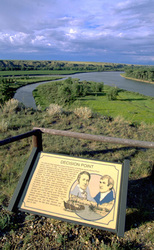 More Images |
On June 2, 1805, Lewis and Clark had their first encounter with the Marias River near present-day Loma. The instructions they had gotten from the Mandan tribe in North Dakota made no mention of the river. The waterway was especially confusing because of its size. Its wide, powerful nature in high water made it seem as likely a main river as the Missouri arm.
The expedition moved on to camp near present-day Fort Benton to explore both forks, hoping to identify the Missouri. While climbing the hills and cliffs of the area, Lewis nearly fell to his death. He recovered his balance, but one of his men had more trouble. After scrambling away from the 90-foot precipice, he heard Private Richard Windsor screaming for help. Lewis advised Windsor to use his knife to dig footholds in the cliff face. Windsor then reached the top.
Lewis climbed to what is now called Decision Point Overlook for a better view of the surrounding land, in hopes of finding the right route. Lewis finally reasoned that the thick, dark waters of the Marias traveled too much to the north to be the Missouri. He felt that the clearer waters of the westward river must move through the high mountains. In the end, it was exploration that decided the matter, and Lewis was proved right.
Lewis cached supplies at the mouth of the Marias for later use. His 1806 return trip took him on an extended exploration of the Marias to the northernmost point reached by the expedition. Jefferson had requested that the expedition look for a natural boundary for a land treaty with the British. Lewis hoped the Marias would end near the 49th Parallel, but his journey ended at Camp Disappointment. Lewis named it Marias River for his cousin, Maria Wood, but it changed over time to Marias.
This area was heavily populated with wildlife. Game was abundant, especially bears. George Drouillard was one of the many expedition members to be chased by a grizzly. Drouillard, or as Lewis called him Drewyer, and John Colter would return to this area as trappers soon after the expedition.
In 1831 Fort Piegan was built to initiate trade with the Blackfeet, but was burned by Indians and abandoned only a year later. Fort McKenzie replaced it, but met with little success, largely due to the smallpox epidemic of 1837.
Directions: Decision Point Overlook is located 11 miles north of Fort Benton on US 87. At the confluence of the Missouri River. The BLM has interpretive signs at Decision Point on the ridge above the Missouri. 1/4 mile hiking trail.
Decision Point
Bureau of Land Management, Lewistown, MT 59457
|
A source for Montana Travel & Tourism Information
![]()