

| Home | Communities | Accommodations | Places To Go | Things To Do | Site Map |
|
Glacier Country
Central Montana
Missouri River Country
Southwest Montana
Yellowstone Country
Southeast Montana
|

Cabinet Mountains Wilderness-USFSLibby MontanaListing Type: Wilderness AreaCity: Libby Montana Region: Glacier Country 406-293-7773 http://www.fs.fed.us/r1/kootenai/ | 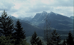 More Images |
The Cabinet Mountains Wilderness occupies the higher reaches of the northern Cabinet Range southwest of Libby. A narrow line of snowcapped peaks, glacial lakes, valleys cut by icy streams, and cascading waterfalls runs north to south for 40 serpentine, up-an-down miles. Two major north-south ridges divide the north Cabinets, sending Lake Creek north to the Kootenai River while spilling the Bull River south to the Clark Fork. A dramatic vertical mile separates lush stream bottoms from the rocky crest of centrally located Snowshoe Peak-the apex of the range at 8,738 feet. These pointed pinnacles challenge technical climbers in a primeval setting. Contiguous wildlands larger than the designated Wilderness core encircle the Wilderness on all sides. The east face runs the length of the range in a row of rugged canyons, from which the Cabinets get their name.
Denizens of this wild, wet land include wolverine, deer, elk, moose, black bear, and a small but threatened grizzly population. Mountain goats in the Cabinet Mountains Wilderness here in Camp Creek and in the dramatic Goat Rocks, with bighorn sheep common near Ibex Peak. The southwest face, containing McKay and Swamp creeks, is important fall range for both mule deer and grizzlies. Mosaics of conifers and hardwoods from a 1910 burn provide forage for grizzly bears and wintering elk.
Some 90 percent of the Cabinet Wilderness visitors travel on foot, with the remainder riding horses or hiking with pack stock. The area's mostly short, steep trails combined with a lack of forage explain the low level of horseback riders in the Cabinets. Two-thirds pack into the high lakes to fish. Most of the 85 lakes in the wilderness contain fish and, as such, are the focal points of use.
Generally, the thirty trails are well maintained. Most of the trails are less than 5 miles long, penetrating east of west and ending in subalpine basins. Most of the available campsites are close to fishable lakes. The most heavily used trails are in the northeast and southern portions. There are ample secluded locations, however, especially on the west side.
Winter recreation in the Cabinets is on the rise. The considerable snow depths and spectacular scenery offer terrific choices for snowshoeing and ski touring. Access routes in the southern third of the Wilderness are generally more popular for winter travel and snow camping.
Directions: How to get there:.West-central.From MT 56 about 23 miles south of Troy and 16 miles north of MT 200, turn east on the South Fork Bull Rover Road (FR 410) and drive 2.2 miles. Turn left (north) and go 0.5 mile on FR 2722 to the turnoff for the Middle Fork Bull River Trail 978. Turn right on this rough two-track and proceed another 0.4 mile to the trailhead at the road's end for Trail 978. To reach the North Fork of Bull River Trail 972 continue up FR2722 another 1.3 miles to the end-of-the-road trailhead
.Southwest.From MT 200, about 0.25 mile northwest of the Cabinet Ranger Station, take the Swamp Creek road due north for 2.2 miles where it joins FR 1119. Go another 2 miles to the end-of-the-road trailhead for the Swamp Creek Trail 912. If approaching from the north take the other end of the Swamp Creek Road loop, which takes off to the east from MT 200, 4 miles north of the Cabinet Ranger Station. After 2.5 miles turn left (north) on FR 1119 to the trailhead.
Cabinet Mountains Wilderness-USFS
Kootenai National Forest, Libby, MT 59923
|
A source for Montana Travel & Tourism Information
![]()