

| Home | Communities | Accommodations | Places To Go | Things To Do | Site Map |
|
Glacier Country
Central Montana
Missouri River Country
Southwest Montana
Yellowstone Country
Southeast Montana
|

Kootenai National ForestLibby MontanaListing Type: National ForestCity: Libby Montana Region: Glacier Country 406-293-6211 http://www.fs.fed.us/r1/kootenai/ | 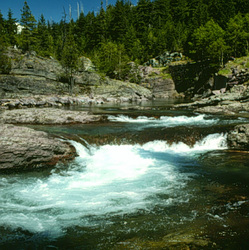 |
The Kootenai National Forest is located in the extreme northwest corner of Montana, bordered on the north by Canada and the west by Idaho. Ranges of high, craggy peaks mark the Forest with 8,738 feet. Snowshoe peak in the Cabinet Mountain Wilderness reaching the highest point. The Whitefish Range, Purcell Mountains, Bitterroot Range, Salish Mountains and Cabinet Mountains are all part of the rugged terrain radiating from the river valleys.
In the north-central part of the Forest, the land is more open, with gently rolling hills and plains lying in the shadows of the Whitefish Range. Alpine meadows, streams and lakes dot the backcountry. The Forest is dominated by two major rivers, the Kootenai and Clark Fork, along with several smaller rivers and their tributaries.
The wildlife and bird life are abundant. There are 191 species of birds that have been recorded. Elk, whitetail and mule deer, mountain goats and bighorn sheep, moose, black bear, mountain lion and grizzly bear roam the forest. Also to be found are coyote, weasel, mink, beaver, otter, squirrel, bobcat, lynx and other smaller mammals.
The Kootenai is heavily forested with a large selection of native trees. Hundreds of plant species have been identified in the Forest ranging from cactus to fairy slipper orchids. Wildflowers abound including favorites such as columbine, violets, phlox and Indian paintbrush.
Directions: Access roads into the Forest are available from US Highways 2 and 93 and Montana State Highways 200, 56, 37, and 508.
Kootenai National Forest
1101 US Highway 2 West, Libby, MT 59923
|
A source for Montana Travel & Tourism Information
![]()