

| Home | Communities | Accommodations | Places To Go | Things To Do | Site Map |
|
Glacier Country
Central Montana
Missouri River Country
Southwest Montana
Yellowstone Country
Southeast Montana
|

Kootenai River Scenic DriveLibby MontanaListing Type: Scenic HighwayCity: Libby Montana Region: Glacier Country 406-293-7773 http://www.fs.fed.us/r1/kootenai/ | 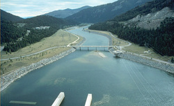 More Images |
This river is regulated by Libby Dam, which supplies water from 90-mile-long Lake Koocanusa. Besides offering a prime trout fishery, the river area affords viewing opportunities for eagles, osprey, deer, and mountain sheep. Three islands are located 2.5 miles down river from Libby that are used by ducks and geese during migrations. Located at Kootenai Falls are a picnic area, viewpoint, and an overpass access to a swinging bridge crossing the river.
Length: 48 miles (one way).Beginning: Junction of Highway 37 and FDR 228 .End: Idaho state line
Area Map: Kootenai National Forest Visitors Map .USGS Map1: Alexander Mountain.USGS Map 2: Leonia
Directions: From Junction Highway 37 and FDR 228 to Idaho state line
Kootenai River Scenic Drive
Kootenai National Forest, Libby, MT 59923
|
A source for Montana Travel & Tourism Information
![]()