

| Home | Communities | Accommodations | Places To Go | Things To Do | Site Map |
|
Glacier Country
Central Montana
Missouri River Country
Southwest Montana
Yellowstone Country
Southeast Montana
|

Kootenai Falls Swinging BridgeLibby MontanaListing Type: LandmarkCity: Libby Montana Region: Glacier Country 406-293-7773 http://www.fs.fed.us/r1/kootenai/ | 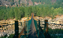 More Images |
Built by the Forest Service to access forest fires across the Kootenai River, this foot bridge was destroyed by a major flood in 1948. The bridge was rebuilt on concrete piers and is now protected from flooding by Libby Dam. Used for administrative purposes, it also offers a breathtaking view of the Kootenai River gorge directly below Kootenai Falls. It is at an elevation of 2,100 feet.
Area Map: Kootenai National Forest Visitors Map .USGS Map1: Kottenai Falls.Township 31N, Range 33W, Section 14
Directions: From Troy, travel east 6 miles on US Highway 2.
Kootenai Falls Swinging Bridge
Kootenai National Forest, Libby, MT 59923
|
A source for Montana Travel & Tourism Information
![]()