

| Home | Communities | Accommodations | Places To Go | Things To Do | Site Map |
|
Glacier Country
Central Montana
Missouri River Country
Southwest Montana
Yellowstone Country
Southeast Montana
|

Bull River Valley Scenic DriveLibby MontanaListing Type: Scenic HighwayCity: Libby Montana Region: Glacier Country 406-293-7773 http://www.fs.fed.us/r1/kootenai/ | 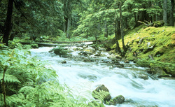 More Images |
This drive provides a relaxing outing with a panorama of the Cabinet Mountains. Driving time should not exceed 1 hour in each direction. All roads are in good condition with paved surfaces. Upon arriving at the end of Highway 56, you may return to US 2 or continue to Idaho or Thompson Falls.
Length: 25 miles (one way) -- Township 31N, Range 33W, Section 20.Elevation: 2300 feet
End: Return, or turn west to Idaho/east to Thompson Falls
Area Map: Kootenai National Forest Visitors Map .USGS Map 1: Kootenai Falls.USGS Map2: Crowell Mountain
Directions: From Troy, follow US Highway 2 east 3 miles to the intersection with Montana 56. Turn south, and drive through the valley for 35 miles.
Bull River Valley Scenic Drive
Kootenai National Forest, Libby, MT 59923
A source for Montana Travel & Tourism Information
![]()