

| Home | Communities | Accommodations | Places To Go | Things To Do | Site Map |
|
Glacier Country
Central Montana
Missouri River Country
Southwest Montana
Yellowstone Country
Southeast Montana
|

Boulder Pass TrailGlacier National Park MontanaListing Type: National Park TrailCity: Glacier National Park Montana Region: Glacier Country 406-888-7800 | 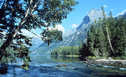 |
Trail follows the shore of Kintla Lake and Upper Kintla Lake. It also provides access to some of the most rugged and beautiful country areas in Glacier Park. It is 11.6 miles and a 400 foot elevation gain from the trailhead to Upper Kintla Lake Campground. The trail will cross Kintla Creek after reaching Upper Kintla Campground at 11.6 miles. At mile 17.2 you will reach Boulder Pass Campground, then .5 mile more is Boulder Pass. The junction campground is .1 mile to the left. Stay to the right for Boulder Pass Trail, which descends moderately steeply into Hole in the Wall. At mile 21.2 is the junction with the trail into Hole in the Wall Campground (0.5 mile). Stay to the left for Brown Pass. From this point Bowman Lake, Olson Creek, Hawksbill Campground, Lake Janet, Waterton Lake Trail, Goat Haunt Ranger Station and Trail, and Rainbow Falls came be accessed.
Length: 30.9 miles.Trail Begins: Kintla Campground.Trail Ends: Waterton Valley Trail
USGS Map1: Park Map
Directions: From the West Glacier Park entrance take Camas Road to Outside North Fork Road, north to Polebridge to Inside North Fork Road. North to Kintla Lake. Trail starts at the Kintla Lake Trailhead.
Boulder Pass Trail
Glacier National Park, West Glacier, MT 59936
|
A source for Montana Travel & Tourism Information
![]()