

| Home | Communities | Accommodations | Places To Go | Things To Do | Site Map |
|
Glacier Country
Central Montana
Missouri River Country
Southwest Montana
Yellowstone Country
Southeast Montana
|

Geiger Lakes TrailLibby MontanaListing Type: National Forest TrailCity: Libby Montana Region: Glacier Country 406-293-7773 http://www.fs.fed.us/r1/kootenai/ | 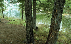 More Images |
The first 0.8 mile of Geiger Lakes Trail (656) is through lodgepole pine, then it opens to subalpine vegetation. Lower Geiger Lake is reached at about 2 miles; the trail continues to Trail 48 which leads to Upper Geiger Lake. This trail connects to Fourth of July Trail 115 and Divide Trail 360, so several circle and one-way trips may be made. Trail 656 climbs and continues to Lost Buck Pass and Trail 360, offering scenic views including an overlook to the west into Wanless Lake. No motorized vehicles are permitted on this trail, and no vehicles are allowed within the wilderness boundary.
Length: 1.5 miles. Heavy use, moderate difficulty
Trail Begins Trailhead.Trail Ends: Junction with Cabinet Divide Trail 360
Area Map: Libby Ranger District Access Map .USGS Map1: Howard Lake.Township 26N; Range 30W; Section 6
Directions: From Libby, travel 26 miles south on US Highway 2. Turn right onto West Fisher Road 231 and continue for 6 miles. Turn left on the Lake Creek road and after 0.5 mile, turn left again on the Geiger Lakes road. Follow 2 miles to the parking area. The trail leaves the road about 100 feet before the parking area.
Geiger Lakes Trail
Kootenai National Forest, Libby, MT 59923
|
A source for Montana Travel & Tourism Information
![]()