

| Home | Communities | Accommodations | Places To Go | Things To Do | Site Map |
|
Glacier Country
Central Montana
Missouri River Country
Southwest Montana
Yellowstone Country
Southeast Montana
|

Leigh Lake TrailLibby MontanaListing Type: National Forest TrailCity: Libby Montana Region: Glacier Country 406-293-7773 http://www.fs.fed.us/r1/kootenai/ | 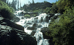 More Images |
Leigh Lake Trail (132) is a short, steep trail that is heavily used as an access point into the Cabinet Mountains Wilderness. Mountain goats are often seen on the slopes above the lake. No camping is allowed at Leigh Lake. No motorized vehicles are permitted on this trail, and no vehicles are allowed within the wilderness boundary.
Length: 1.5 miles. Heavy use, moderate difficulty
Trail Begins: End of Road 4786.Trail Ends: Leigh Lake
Area Map: Libby Ranger District Access Map .USGS Map1: Snowshoe Peak.Township 28N; Range 31W; Section 6
Directions: From Libby, travel 7 miles south on US Highway 2. Turn right on the Bear Creek road and travel 3 miles to Cherry Creek Road 867. Turn right and follow for approximately 4 miles. Turn right on Leigh Creek Road 4786 and follow 2 miles to the trailhead.
Leigh Lake Trail
Kootenai National Forest, Libby, MT 59923
|
A source for Montana Travel & Tourism Information
![]()