

| Home | Communities | Accommodations | Places To Go | Things To Do | Site Map |
|
Glacier Country
Central Montana
Missouri River Country
Southwest Montana
Yellowstone Country
Southeast Montana
|

Fisher Divide TrailLibby MontanaListing Type: National Forest TrailCity: Libby Montana Region: Glacier Country 406-293-7773 http://www.fs.fed.us/r1/kootenai/ | 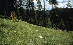 More Images |
Fisher Divide Trail (5.1) is best suited to horseback or mountain bike use, though it is also a fine hiking experience and is mostly located on or near ridge tops, which offer beautiful views of the Cabinet Mountains.
Length: 11.5 miles. Light use, low difficulty
Trail Begins: Teepee Lake.Trail End: Just below top of Brush Mountain
Area Map: Kootenai National Forest Visitors Map .USGS Map1: Horse Mountain.Township 28N; Range 29W; Section 25
Directions: From Libby, travel 20.5 miles southeast on US Highway 2. Turn left on Tepee Creek Road 6740 and travel 7.3 miles to Tepee Lake. The trail is signed and takes off near the eastside of the lake. It begins as an old two-track road.
Fisher Divide Trail
Kootenai National Forest, Libby, MT 59923
|
A source for Montana Travel & Tourism Information
![]()