

| Home | Communities | Accommodations | Places To Go | Things To Do | Site Map |
|
Glacier Country
Central Montana
Missouri River Country
Southwest Montana
Yellowstone Country
Southeast Montana
|

Northwest Peak TrailLibby MontanaListing Type: National Forest TrailCity: Libby Montana Region: Glacier Country 406-293-7773 http://www.fs.fed.us/r1/kootenai/ | 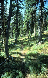 More Images |
The lower half of Northwest Peak Trail (169) is the easiest climb, with an average grade of 10 percent; the climb to the top of Northwest Peak has grades from 10 to 35 percent. Drinking water is not available enroute. The trail is closed to motorized travel from April 1 to November 30.
Length: 2.3 miles.Trail Begins: Forest Road 538.Trail Ends: Northwest Peak
Area Map: Kootenai National Forest Visitors Map .USGS Map1: Northwest Peak.Township 37N; Range 33W; Section 17
Directions: From Troy, travel west 10 miles on US Highway 2. Turn onto Highway 508/Yaak Road 92 and follow to Pete Creek Road 338. Turn northwest and follow this road for approximately 22 miles to the trailhead. Parking is available for 2 vehicles.
Northwest Peak Trail
Kootenai National Forest, Libby, MT 59923
|
A source for Montana Travel & Tourism Information
![]()