

| Home | Communities | Accommodations | Places To Go | Things To Do | Site Map |
|
Glacier Country
Central Montana
Missouri River Country
Southwest Montana
Yellowstone Country
Southeast Montana
|

Goat Mountain Trail #148Libby MontanaListing Type: National Forest TrailCity: Libby Montana Region: Glacier Country 406-293-7773 http://www.fs.fed.us/r1/kootenai/ | 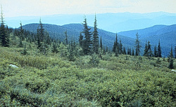 |
Goat Mountain Trail (148) follows a creek bed for 0.3 mile. The trail soon changes to a moderately steep hike. It follows a sidehill with narrow tread in a few spots. From the top of Goat Mountain one can view the Cabinet Mountains.
Length: 1.5 miles.Trail Begins: Road 4555 .Trail Ends: Goat Mountain
Area Map: Kootenai National Forest Visitors Map .USGS Map1: Troy.Township 31N; Range 34W; Section 33
Directions: From the junction of US Highway 2 and Iron-Grouse road, travel south on Iron-Grouse 4 miles to the junction with FS Road 4555. Turn and follow to the trailhead.
Goat Mountain Trail #148
Kootenai National Forest, Libby, MT 59923
|
A source for Montana Travel & Tourism Information
![]()