

| Home | Communities | Accommodations | Places To Go | Things To Do | Site Map |
|
Glacier Country
Central Montana
Missouri River Country
Southwest Montana
Yellowstone Country
Southeast Montana
|

Yaak FallsLibby MontanaListing Type: National Forest Day AreaCity: Libby Montana Region: Glacier Country 406-293-7773 http://www.fs.fed.us/r1/kootenai/ | 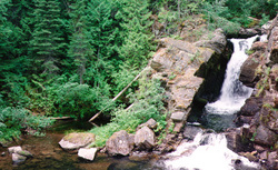 More Images |
This waterfall is the highlight for many visitors as they tour through the Yaak area. During spring and early summer tremendous viewing opportunities abound in the Yaak River area as snowmelt follows its way down and over the falls. For any photographer, this is one sight that shouldn't be missed. This site can be found on a Kootenai National Forest Visitors Map at Township 33N, Range 33W, Section 9.
The Yaak Falls, named after the Yaak Indians who once populated this remote area of Montana, has always been a favorite stop on the scenic tour of northwest Montana. This beautifully cascading waterfall was created by the eastward shift of the Pacific plate. As a result of this shifting, some of the oldest rock in the world is exposed. The rock is dated between 800 million and one and a half billion years old. . .This area is rich in local history, dating back to the 1880s. Part of an old bridge can be seen just below the falls. This bridge was the first structure to span the Yaak River. This allowed unrestricted passage from Troy to another important mining town called Sylvanite. Many placer mining camps, including one called 'Snipe Town', operated near the falls in the 1890s. In 1910 a devastating fire destroyed mining operations around the falls area.
Directions: From Troy, travel west approximately 8 miles on US Highway 2. Turn onto Montana 508 and travel 7 miles.
Yaak Falls
Kootenai National Forest, Libby, MT 59923
|
A source for Montana Travel & Tourism Information
![]()