

| Home | Communities | Accommodations | Places To Go | Things To Do | Site Map |
|
Glacier Country
Central Montana
Missouri River Country
Southwest Montana
Yellowstone Country
Southeast Montana
|

Hoskins Lake TrailLibby MontanaListing Type: National Forest TrailCity: Libby Montana Region: Glacier Country 406-293-7773 http://www.fs.fed.us/r1/kootenai/ | 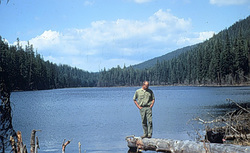 More Images |
Along Hoskins Lake Trail (162) hikers and fisherpersons gain easy access to lake fishing. There are no steep hills or hazards making this an ideal hike for small children or less experienced hikers. Camping areas are available within 100 yards of the water at either end of the lake; a path offers practical access to the west side. There is no developed drinking water.
Length: 1.9 miles.Trail Begins: Road 746.Trail Ends: Road 746
Area Map: Kootenai National Forest Visitors Map .USGS Map1: Boulder Lake.Township 36N; Range 31W; Section 17
Directions: Drive west of Libby on US Highway 2 for 29 miles (through Troy) and turn right, heading north on Yaak River Road. After approximately 29.5 miles turn right, heading south on South Fork of the Yaak River Road, Forest Road 68, for 4.2 miles, then turn left, heading north on Venal Lake Forest Road 746 and travel 7.3 miles north. Parking is available for 3 vehicles at the trailhead.
Hoskins Lake Trail
Kootenai National Forest, Libby, MT 59923
|
A source for Montana Travel & Tourism Information
![]()