

| Home | Communities | Accommodations | Places To Go | Things To Do | Site Map |
|
Glacier Country
Central Montana
Missouri River Country
Southwest Montana
Yellowstone Country
Southeast Montana
|

Judith Landing Recreation AreaBig Sandy MontanaListing Type: B.L.M. Recreation AreaCity: Big Sandy Montana Region: Central Montana 406-538-7461 http://www.mt.blm.gov/ldo | 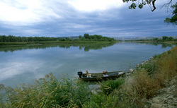 More Images |
The Judith Landing Recreation Area is an access point midway in the Upper Missouri National Wild and Scenic River corridor. At an elevation of 2,400 feet, the recreation area encompasses 3 acres. Judith Landing has 12 campsites, potable water, a restroom, and a boat ramp. The river is the actual route taken by Lewis and Clark and identified as part of the Lewis and Clark National Historic Trail. This area contains the site of the PN Bridge, a major river crossing between Big Sandy on the north and Winifred on the south. Campground and boat ramp are located here along the Upper Missouri National Wild and Scenic River. Nearby historic sites include the PN Ranch, Fort Chardon, Fort Clagett, Camp Cooke, Council Island and the Judith Landing Historic District. Pets are welcome, and fishing is allowed. Please limit your stay to 14 days.
Directions: Judith Landing Recreation Area is located along Montana Highway 236 between Winifred and Big Sandy, Montana where the PN Bridge crosses the Missouri River. It is 26 miles northwest of Winifred on Montana Highway 236.
Judith Landing Recreation Area
Bureau of Land Management, Lewistown, MT 59457
|
A source for Montana Travel & Tourism Information
![]()