

| Home | Communities | Accommodations | Places To Go | Things To Do | Site Map |
|
Glacier Country
Central Montana
Missouri River Country
Southwest Montana
Yellowstone Country
Southeast Montana
|

Custer National ForestBillings MontanaListing Type: National ForestCity: Billings Montana Region: Southeast Montana 406-657-6200 http://www.fs.fed.us/r1/custer/ | 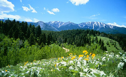 More Images |
The lands of the Custer National Forest and National Grasslands lie within 20 counties of Montana, North Dakotas and South Dakota. They are scattered from the northeast corner of Yellowstone National Park to the southeastern corner of North Dakota. Elevations range from sea level to 12,799 feet at Granite Peak, the highest point in Montana.
Custer National Forest contains 1,278,279 acres. The Forest is rich in the history of the west, Indian hieroglyphics and burial grounds. This Forest also contains portions of the Absaroka-Beartooth Wilderness Area and the Grand River, Cedar River, Little Missouri and Cheyenne National Grasslands.
Big-game species found in the area include bear, elk, moose, big horn sheep, mule and whitetail deer and Rocky Mountain goat. Along the trails, naturalists and photographers can see a variety of songbirds, hawks, eagles and owls. In shaded groves, along quiet pools and out on the windswept range, gophers, chipmunks, beaver, porcupine, woodchucks, rabbits, squirrels and other animals can be watched and photographed.
Custer National Forest
1310 Main Street, Billings, MT 59105
|
A source for Montana Travel & Tourism Information
![]()