

| Home | Communities | Accommodations | Places To Go | Things To Do | Site Map |
|
Glacier Country
Central Montana
Missouri River Country
Southwest Montana
Yellowstone Country
Southeast Montana
|

Big Creek TrailEureka MontanaListing Type: National Forest TrailCity: Eureka Montana Region: Glacier Country 406-296-2536 http://www.fs.fed.us/r1/kootenai/ | 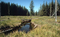 More Images |
Big Creek Trail (150) is primarily a creek bottom hike for 80 percent of the hike. Hiking is relatively easy until you leave the creek bottom and climb up to the trailhead on Road 7183. Fishing for small (4 to 8 inches) trout is available on the North Fork of Big Creek. A good campsite is available at the lower trailhead, but camping is limited along the trail. Hiking in and out along the creek bottom makes a good family hike.
Length: 4.5 miles. Moderate difficulty, light use
Trail Begins: Road 150.Trail Ends: Road 7183
Area Map: Kootenai National Forest Visitors Map .USGS Map1: Boulder Lakes.Township 35N, Range 30W, Section 28
Directions: From Highway 37, cross Koocanusa Bridge and travel South on FDR 228 for 8 miles. Turn at Junction with Big Creek Road 336 and follow 6.1 miles to the spur road just before North Fork Big Creek bridge. The trailhead is at the end of this short spur road
.Another way to access the trail is to proceed north for 2.3 miles after crossing Kookanusa Bridge to the junction with Boulder Creek Road 337. Turn and follow this road for 34 miles to the junction with the trailhead below Lost Horse Mountain.
Big Creek Trail
Kootenai National Forest, Eureka, MT 59917
|
A source for Montana Travel & Tourism Information
![]()