

| Home | Communities | Accommodations | Places To Go | Things To Do | Site Map |
|
Glacier Country
Central Montana
Missouri River Country
Southwest Montana
Yellowstone Country
Southeast Montana
|

Sunday Falls TrailFortine MontanaListing Type: National Forest TrailCity: Fortine Montana Region: Glacier Country 406-882-4451 http://www.fs.fed.us/r1/kootenai/ | 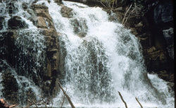 More Images |
Sunday Falls Trail (100) is an easily reached trail that leads to a series of waterfalls. It is one of the more popular hikes for local area residents. Visitors will see old-growth cedar, larch, Douglas-fir, and spruce trees along the trail as well as Pacific yew, western hemlock, and a wide variety of riparian-inhabiting plants and birds.
Length: 0.5 miles.Trail Begins: Sunday Creek Bridge.Trail Ends: Second waterfall
Area Map: Kootenai National Forest Visitors Map .USGS Map 1: Bull Lake.Township 33N, Range 24W, Section 18
Directions: From Stryker, travel south 3.5 miles on Road 315. Turn onto Road 3738 and follow 0.25 mile to the bridge. Parking is available for 6 vehicles.
Sunday Falls Trail
Kootenai National Forest, Fortine, MT 59918
|
A source for Montana Travel & Tourism Information
![]()