

| Home | Communities | Accommodations | Places To Go | Things To Do | Site Map |
|
Glacier Country
Central Montana
Missouri River Country
Southwest Montana
Yellowstone Country
Southeast Montana
|

Kinney Coulee Hiking TrailGlendive MontanaListing Type: State Park TrailCity: Glendive Montana Region: Southeast Montana 406-377-6256 | 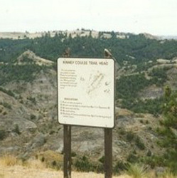 |
Kinney Coulee Hiking Trail is a marked trail that descends 300 feet to the bottom of a badlands coulee
Length: 0.5 miles.Trail Begins: Left at Radio Hill Junction, then first dirt road to right will bring you to Kinney Coulee Trailhead
Trail Ends: Bottom of Kinney Coulee
USGS Map1: Glendive, Montana.Township 15N; Range 56E; Section 18
Directions: Makoshika State Park is located 1/4 mile southeast of Glendive. Take I-94 Glendive Exits and follow signs two to three miles through town to Makoshika State Park. Makoshika is adjacent to the southeast city limits.
Kinney Coulee Hiking Trail
1301 Snyder Avenue, Glendive, MT 59330
|
A source for Montana Travel & Tourism Information
![]()