

| Home | Communities | Accommodations | Places To Go | Things To Do | Site Map |
|
Glacier Country
Central Montana
Missouri River Country
Southwest Montana
Yellowstone Country
Southeast Montana
|

Martin Lake TrailFortine MontanaListing Type: National Forest TrailCity: Fortine Montana Region: Glacier Country 406-882-4451 http://www.fs.fed.us/r1/kootenai/ | 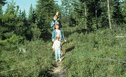 More Images |
Martin Lake Trail (418) provides easy access to a low elevation, isolated lake. Loons may be seen as well as moose, ducks, and other wildlife. This is an excellent hike for the first-time camper/hiker.
Length: 0.5 mile.Trail Begins: Road 7007.Trail Ends: Martin Lake
Area Map: Kootenai National Forest Visitors Map .USGS Map1: Mount Marston .USGS Map2: Stryker.Township 35N; Range 25W; Section 33
Directions: From Murphy Lake Ranger Station, travel north 0.25 mile on US Highway 93. Turn onto Laughing Water Road 7008 and follow for approximately 3 miles to Road 7007. Turn and follow .75 mile to the trailhead. Parking is available for four vehicles.
Martin Lake Trail
Kootenai National Forest, Fortine, MT 59918
|
A source for Montana Travel & Tourism Information
![]()