

| Home | Communities | Accommodations | Places To Go | Things To Do | Site Map |
|
Glacier Country
Central Montana
Missouri River Country
Southwest Montana
Yellowstone Country
Southeast Montana
|

Rainbow Lake TrailFortine MontanaListing Type: National Forest TrailCity: Fortine Montana Region: Glacier Country 406-882-4451 http://www.fs.fed.us/r1/kootenai/ | 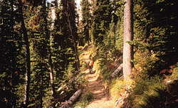 |
Rainbow Lake Trail (89) provides tremendous vistas of the Wigwam drainage, Galton Range, and especially the Ten Lakes basin. The visitor will also have overviews of Rainbow Lake, Bean Lake, and several other alpine lakes. The trail ends at the base of Poorman Mountain, the highest peak in the Ten Lakes Scenic Area.
Length: 5.0 miles.Trail Begins: Road 7091.Trail Ends: Trail 88
Area Map: Kootenai National Forest Visitors Map .USGS Map1: Stahl Peak.Township 37N; Range 25W; Section 10
Directions: From Fortine, travel north 3 miles on US Highway 93. Turn onto Grave Creek Road 114 and follow for 14 miles, then turn onto Therriault Lakes Road 319 and follow for 14 miles. Turn onto Wolverine Creek Road 7086 and travel approximately 2 miles. Turn onto Road 7091, and the trailhead. There is a turnaround for a small horse trailer and parking for four vehicles.
Rainbow Lake Trail
Kootenai National Forest, Fortine, MT 59918
|
A source for Montana Travel & Tourism Information
![]()