

| Home | Communities | Accommodations | Places To Go | Things To Do | Site Map |
|
Glacier Country
Central Montana
Missouri River Country
Southwest Montana
Yellowstone Country
Southeast Montana
|

Cliff Point TrailEureka MontanaListing Type: National Forest TrailCity: Eureka Montana Region: Glacier Country 406-296-2536 http://www.fs.fed.us/r1/kootenai/ | 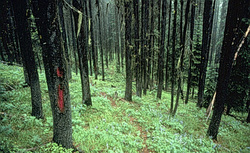 |
From the lower trailhead, Cliff Point Trail (436) climbs a sidehill through a series of three switchbacks for 2.5 miles to Cliff Point, then follows the ridgeline between Little North Fork/Big Creek and Gold Creek drainages to the upper trailhead on Road 751. Both trails have adequate space for parking. Potential dispersed campsites can be found along the ridge, but water is not available. Due to mountain pine beetles, dead trees are falling; therefore, it is not recommended the trail be used on windy days.
Length: 6.0 miles. Moderate difficulty, light use
Trail Begins: Road 228.Trail Ends: Road 751
Area Map: Kootenai National Forest Visitors Map .USGS Map1: Webb Mountain.Township 35N; Range 29W; Section 26
Directions: From Rexford, South 7 miles on Highway 37 to Koocanusa Bridge. Cross the bridge and travel South on FDR 228 for 4.8 miles to Junction with the lower trailhead
.The second way to access the trail is, after crossing Kookanusa Bridge, to proceed north on Highway 92 for 2.3 miles to the junction with Boulder Creek Roar 337. Follow for 7 miles to the junction with Webb Mountain Road 7179 and proceed 2.3 miles to the saddle and junction with Road 1921. Follow for 2.6 miles to the junction with Road 751 and turn south for 0.3 miles to the trailhead.
Cliff Point Trail
Kootenai National Forest, Eureka, MT 59917
|
A source for Montana Travel & Tourism Information
![]()