

| Home | Communities | Accommodations | Places To Go | Things To Do | Site Map |
|
Glacier Country
Central Montana
Missouri River Country
Southwest Montana
Yellowstone Country
Southeast Montana
|

McGuire Mountain TrailEureka MontanaListing Type: National Forest TrailCity: Eureka Montana Region: Glacier Country 406-296-2536 http://www.fs.fed.us/r1/kootenai/ | 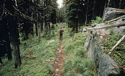 |
McGuire Mountain Trail is an easy hike with very few steep pitches. It follows McGuire Creek for the entire length and is close to the creek the last 2 miles. Trail length depends on snow plowing of access road. Limited parking.
Length: 5.6 to 15.1 km of more difficult trail; no grooming. .Trail Begins: 0.3 mile up McGuire Creek off Highway 37.Trail Ends: Upper fork of McGuire Creek
Area Map: Kootenai National Forest Visitors Map .USGS Map1: Inch Mountain .USGS Map2: McGuire Mountain.Township 34N; Range 28W; Section 22
Directions: From Eureka, south 24 miles on Highway 37 to Junction with McGuire Creek Road 14099. Turn east and proceed .3 mile to the trailhead
.From Libby, north 41 miles on Highway 37.
McGuire Mountain Trail
Kootenai National Forest, Eureka, MT 59917
|
A source for Montana Travel & Tourism Information
![]()