

| Home | Communities | Accommodations | Places To Go | Things To Do | Site Map |
|
Glacier Country
Central Montana
Missouri River Country
Southwest Montana
Yellowstone Country
Southeast Montana
|

South Fork Ross Creek TrailTroy MontanaListing Type: National Forest TrailCity: Troy Montana Region: Glacier Country 406-293-7773 http://www.fs.fed.us/r1/kootenai/ | 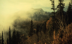 More Images |
After fording Ross Creek, South Fork Ross Creek Trail (321) is overgrown and somewhat difficult to find. Once located, the trail is easy to follow to a waterfall and potential campsite. The trail follows the creek the entire way. The side slope is eroded in a few places and should be hiked with caution.
Length: 2.0 miles.Trail Begins: Trail 142.Trail Ends: Junction Trail 321 and Trail 142
Area Map: Kootenai National Forest Visitors Map .USGS Map1: Sawtooth Mountain.Township 28N; Range 34W; Section 15
Directions: From junction of Montana Highway 56 and Road 398, follow Road 398 to the Ross Creek Scenic Area. Follow the nature trail to Trail 142. The South Fork trail intersects Trail 142 approximately 2 miles from this junction.
South Fork Ross Creek Trail
Kootenai National Forest, Libby, MT 59923
|
A source for Montana Travel & Tourism Information
![]()