

| Home | Communities | Accommodations | Places To Go | Things To Do | Site Map |
|
Glacier Country
Central Montana
Missouri River Country
Southwest Montana
Yellowstone Country
Southeast Montana
|

West Fork Canyon Creek TrailTrout Creek MontanaListing Type: National Forest TrailCity: Trout Creek Montana Region: Glacier Country 406-827-3533 http://www.fs.fed.us/r1/kootenai/ | 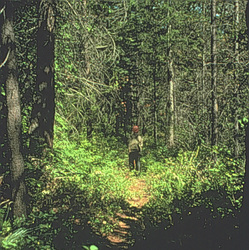 |
West Fork Canyon Creek Trail (892) follows an overgrown mining road to an historical mine site, and gradually steepens the last 5 miles to the ridgetop. Several creek crossings make it a wet feet trail, ending on a ridgetop with a view of the Cabinet Mountains. It is a good access trail leading to Canyon Peak/Baree Mountain in one direction and 20-Odd Peak in the other.
Length: 4.2 miles.Trail Begins: Road 2211.Trail Ends: Trail 903
Area Map: Kootenai National Forest Visitors Map .USGS Map1: Trout Creek.Township 24N; Range 30W; Section 6
Directions: From Trout Creek, W .5 mile on Highway 200 to the Blue Slide Road. Turn and Follow Vermilion River Road 154 to the junction with '20-Odd' Road 2211, approximately 7 miles. Turn left and go .75 mile to the signed trailhead.
West Fork Canyon Creek Trail
Kootenai National Forest, Trout Creek, MT 59874
|
A source for Montana Travel & Tourism Information
![]()