

| Home | Communities | Accommodations | Places To Go | Things To Do | Site Map |
|
Glacier Country
Central Montana
Missouri River Country
Southwest Montana
Yellowstone Country
Southeast Montana
|

Landers Fork TrailLincoln MontanaListing Type: National Forest TrailCity: Lincoln Montana Region: Southwest Montana 406-362-4265 http://www.fs.fed.us/r1/helena/ | 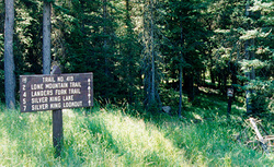 More Images |
The Landers Fork Trail begins at Indian Meadows trailhead, goes approximately 2 miles to the east, crosses the Landers Fork, then follows this river north into the Scapegoat Wilderness.
Length: 15.6 miles.Trail Begins: Forest Road 1882.Trail Ends: Trail Junction 441, 207
Area Map: Helena Forest Visitor Map .USGS Map1: Silver King Mountain.USGS Map2: Heart Lake Mountain .USGS Map3: Stonewall Mountain.Township 15N; Range 8W; Section 4
Directions: Travel east of Lincoln on State Highway 200 approximately 6 miles, then north on Copper Creek Road (Forest Road 330) approximately 10 miles to the Indian Meadows Trailhead.
Landers Fork Trail
Helena National Forest, Lincoln, MT 59639
|
A source for Montana Travel & Tourism Information
![]()