

| Home | Communities | Accommodations | Places To Go | Things To Do | Site Map |
|
Glacier Country
Central Montana
Missouri River Country
Southwest Montana
Yellowstone Country
Southeast Montana
|

Snowbank TrailLincoln MontanaListing Type: National Forest TrailCity: Lincoln Montana Region: Southwest Montana 406-362-4265 http://www.fs.fed.us/r1/helena/ | 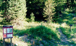 More Images |
Snowbank Trail is a very good hiking trail that is also used by motorcyclists and horse users. It begins at Snowbank Lake and soon reaches and old clear-cut. The trail is not defined here, but looks across the clear-cut and you will see a Forest Service blaze mark where the trail takes off through the Forest. The first 2 miles of trail follows Snowbank Creek and the walking is easy. Many smaller creeks intersect the trail, so use caution when crossing them. The trail begins to get steeper after crossing the last creek and continues this way up to the ridge. From this point to the end of the trail (3.2 miles away) the hike is down hill, somewhat steep in a few places, but easy to follow. The trail ends at an old 4x4 road that you can follow down to the Sucker Creek Road 1800.
Length: 9.0 miles.Trail Begins: Snowbank Creek near Snowbank Lake.Trail Ends: County Road 601
Area Map: Helena Forest Visitor Map .USGS Map1: Swede Gulch.USGS Map2: Silver King Mountain.Township 14N; Range 8W; Section 6
Directions: From State Highway 200 take the Copper Creek Road 330 north 9 miles to Snowbank Lake. The trail begins on the northwest side of the parking area.
Snowbank Trail
Helena National Forest, Lincoln, MT 59639
|
A source for Montana Travel & Tourism Information
![]()