

| Home | Communities | Accommodations | Places To Go | Things To Do | Site Map |
|
Glacier Country
Central Montana
Missouri River Country
Southwest Montana
Yellowstone Country
Southeast Montana
|

Blackfoot Meadows TrailHelena MontanaListing Type: National Forest TrailCity: Helena Montana Region: Southwest Montana 406-449-5490 http://www.fs.fed.us/r1/helena/ | 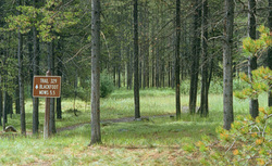 |
This attractive trail, Upper Little Blackfoot (329) offers a wide variety of trips. The trail goes up a moist wooded valley along the Little Blackfoot River. The first miles are a wide trail and relatively easy to moderate hiking. This 5-mile hike goes to the Blackfoot Meadows and pond. The meadows are a beautiful place to picnic, fish, or camp overnight. Fish are small in the pond and river but plentiful. Beaver dams abound along the river and in the meadows. Bear grass can be found in bloom early in the summer. Insect repellant will be quite helpful at the meadow. Bring iodine-type purification tablets and a water bottle, if you plan to drink stream water. Animals such as beaver, elk, cows, horses, and man use the stream. Hiking boots are recommended. The first river crossing has a footbridge but the second crossing one will have to ford.
This is a beautiful moist wooded valley with most of the trail in young lodgepole pine forest with ground cover of grouse whortleberry. The Little Blackfoot River is less than 20 feet wide at the trailhead, falling over rocks into still but deep pools.
Kading Campground is a popular place to camp about a .5 mile before the trailhead. Approximately 1.5 miles up the trail before the first crossing of the river is another well-developed campsite. Three more campsites are at the Little Blackfoot Meadows. Two of the latter are on high wooded sites overlooking the ponds. No campsites are on the upper 5 miles of the trail. Cottonwood Lake is a pleasant place to camp 1 mile south of the Continental Divide on the trail heading to Whitehouse Campground.
The Blackfoot Meadows pond was formed by an old log and rock-filled dam. The spillway is a tangle of dead trees, raising the pond level and flooding the meadows. There is another similar dam about .3 miles downstream from the pond but the river has gone around this dam draining much of this swamp. The main swampy areas are now upstream from the pond. Wondering how the dams got here and their purpose' Two men worked on the actual construction and raised beaver for about 5 years. They had planned to build a fish hatchery too.
Using the Larabee Trail 359 does a popular loop trail. Take Upper Little Blackfoot 329 to the meadows; next Trail 362 to the top of the ridge then cut-off along the ridge, Larabee Trail 359, down the Larabee Gulch. Three switchbacks on Trail 359 make this a good trail. Total length of this loop is about 13 miles, finishing just 2 miles from the start of your hike. Check with Helena Ranger District for more information.
Trail begins at Forest Road 227 and ends at Trail Junction 65. Maps of the area are the Helena National Forest Visitor Map, USGS Map: Bison Mountain and USGS Map2: Thunderbolt Creek.
Directions: Travel 1 mile east of Elliston on Highway 12 to Forest Road 227, travel south approximately 17 miles along the Little Blackfoot River to the end of the road and trailhead.
Blackfoot Meadows Trail
Helena National Forest, Helena, MT 59601
|
A source for Montana Travel & Tourism Information
![]()