

| Home | Communities | Accommodations | Places To Go | Things To Do | Site Map |
|
Glacier Country
Central Montana
Missouri River Country
Southwest Montana
Yellowstone Country
Southeast Montana
|

Meriwether Canyon TrailHelena MontanaListing Type: National Forest TrailCity: Helena Montana Region: Southwest Montana 406-449-5490 http://www.fs.fed.us/r1/helena/ | 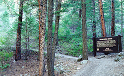 More Images |
The Meriwether Canyon Trail follows Meriwether Canyon into the Gates of the Mountains Wilderness. The Meriwether Picnic Area is a popular picnic site on the Missouri River in the Gates of the Mountains area, featuring soaring limestone cliffs. Several picnic sites, a picnic shelter, fire grills, toilets, and potable water. Lenght of trail is 6.0 miles and begins at Trail Junction 257, Meriwether Day Use Area, ending at Trail Junction 252.
Area maps are Helena National Forest Visitor Map, Gates of the Mountains Wilderness and Recreation Area Map, also USGS Map1: Upper Holter Lake, USGS Map2: Nelson, Township 13N; Range 2W; Section 19.
Directions: Trail begins at Meriwether Picnic Area, which is accessible by private boat or tour boat from the Gates of the Mountains Boat Club on Holter Lake. To get to Holter Lake travel north of Helena on I-15 approximately 15 miles to the Gates of the Mountains exit, then east approximately 3 miles to the boat club.
Meriwether Canyon Trail
Helena National Forest, Helena, MT 59601
|
A source for Montana Travel & Tourism Information
![]()