

| Home | Communities | Accommodations | Places To Go | Things To Do | Site Map |
|
Glacier Country
Central Montana
Missouri River Country
Southwest Montana
Yellowstone Country
Southeast Montana
|

Trapper Peak TrailDarby MontanaListing Type: National Forest TrailCity: Darby Montana Region: Glacier Country 406-821-3269 http://www.fs.fed.us/r1/bitterroot/ | 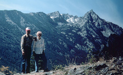 |
Trapper Peak Trail (133) is maintained every two years. Difficult, steep trail that gets moderate to high use. The climb to Trapper Peak, the highest peak in the Bitterroot Ranger at 10,157 feet, is a steep, strenuous hike. Beyond the wilderness boundary the trail becomes indistinguishable, but is marked by cairns. It is necessary to pack water as there is none along the trail. Trapper Peak Trail is unsuitable for stock use. The view from Trapper Peak encompasses much of west-central Montana and central Idaho.
Length: 1.2 miles.Trail Begins: Forest Road 5630A.Trail Ends: Trapper Peak
Area Map: Bitterroot National Forest Visitors Map .USGS Map1: Boulder Peak.USGS Map2: Trapper Peak.Township 1N; Range 21W; Section 7
Directions: Four miles south of Darby, take the West Fork Road 473 for 11 miles to Trapper Peak Road 5630. The trailhead is at the end of the road.
Trapper Peak Trail
Bitterroot National Forest, Darby, MT 59829
|
A source for Montana Travel & Tourism Information
![]()