

| Home | Communities | Accommodations | Places To Go | Things To Do | Site Map |
|
Glacier Country
Central Montana
Missouri River Country
Southwest Montana
Yellowstone Country
Southeast Montana
|

Canyon Ferry ReservoirHelena MontanaListing Type: LakeCity: Helena Montana Region: Southwest Montana 406-475-3921 http://www.usbr.gov/gp | 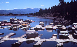 More Images |
Canyon Ferry has become one of Montana's foremost recreation areas because of its proximity to Helena, Great Falls and Butte. The reservoir covers 25 miles and there are 24 Bureau of Reclamation maintained recreation sites around the reservoir. There is east access to the reservoir from US Highway 12 east of Helena or just north of Townsend.
Canyon Ferry offers a variety of recreational opportunities including boating, year-round fishing for trout and salmon, camping, sightseeing, picnicking, hiking, hunting, waterskiing, nature study, and swimming. Boat access is available at all of the campsites. A number of additional public boat launch areas are located near the dam on the north end and near Townsend on the south end. A Sapphire mine, laundromat, dining, entertainment, cabins, beaches, house boats, showers, and grocery stores are available in the area.
Lewis and Clark's passage of the river from the Gates of the Mountains to the three forks takes in the Townsend and Missouri River Valley areas. The upriver passage in the Helena vicinity was maddeningly slow for the Corps of Discovery. On July 22, Sacagawea recognized the white clay banks east of present day Winston, Montana. In her youth, her people visited the banks to gather clay for pigment. Beginning on the south end of Canyon Ferry Reservoir to the Toston Dam, Lewis and Clark set up nine campsites along this short distance in their travels between July 21 and July 25. Those sites were located near present day Canyon Ferry Dam, a site 2 3/4 miles above Beaver Creek, an island below Bedford and a site near Dry Creek south of Townsend. Entries in their journals refer to Onion Island, Crimson Bluffs, York's Island, Fine Bold Springs, and Little Gates of the Mountains. On July 24th, Captain Lewis referred to the 'adjacent mountains' - these are the Big Belts to the east and to the west is the Elkhorns -- now part of the Helena National Forest.
Directions: Canyon Ferry Reservoir is located approximately 20 miles east of Helena. Take Highway 12 south for 10 miles, turn east on Highway 287, approximately 8 miles to dam.
Canyon Ferry Reservoir
Bureau of Reclamation, Helena, MT 59602
|
A source for Montana Travel & Tourism Information
![]()